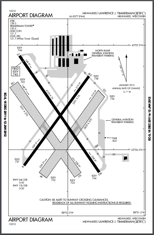
Milwaukee County's Timmerman Airport


  • About
    • Photo Gallery
    • History
    • Timmerman News & Events
    • Airport Projects
    • UAS & Drones
    • Contact Us
  • Services
    • Flight School
    • Charter
    • Fuel & Line Services
    • Maintenance
  • Area Info
    • Local Restaurants
    • Milwaukee Maps
    • Public Transportation
    • Transportation Services
    • Local Hotels
    • Local Area Events
  • Flight Planning
    • Airfield Map
    • Tower
    • FBO
    • Contact Info & Airport Frequencies
    • Fuel & Line Services
  • Hangars & Aircraft
    • Hangars
    • Aircraft
  • Contact Us
  1. Home
  2. Flight Planning
  3. Airfield Map

Airfield Map

Runways

15L-33R
4,106 x 75 (hard surface)


15R-33L
3,254 x 275 (turf)


4L-22R
3,202 x 75 (hard surface)


4R-22L
2,862 x 275 (turf)

Contact Us

Spring City Aviation - Milwaukee 
9305 West Appleton Avenue
Milwaukee, Wisconsin  53225


P  414-461-3222
F  414-461-8207

info@flymilwaukee.com

Hours

Monday – Friday
7am – 6pm


Airport Diagram

For reference ONLY - Not for navigation

Download PDF

airport-diagram.jpg

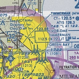
Timmerman Airport Sectional Map

Interact with Map


timmerman-sectional-map.jpg


AOPA Online.png

AOPA - Aircraft Owners & Pilots Association

Additional navigational info, including approach procedures are available at AOPA.org
 

  • Flight Planning
  • Airfield Map
  • Tower
  • FBO
  • Contact Info & Airport Frequencies
  • Fuel & Line Services

Timmerman Airport | 9305 W Appleton Ave, Milwaukee, WI 53225 | 414-461-3222

Copyright © 2023 | Privacy Policy | Cookies Policy


Mitchell Airport   Milwaukee County Empowering People. Strengthening Community.
Close

By using our website you are consenting to our use of cookies in accordance with our cookies policy.